On the evening of December 5, 2013, residents of Tamsui, a picturesque coastal town in northern Taiwan, reported hearing three loud, explosion-like sounds in quick succession. The source of these mysterious booms baffled everyone. Despite searches and speculation, no clear explanation emerged. However, as a researcher studying geophysical phenomena, I found these unexplained sounds deeply intriguing. This curiosity led to the research project that lead to our 2017 paper, “A meteor shockwave event recorded at seismic and infrasound stations in northern Taiwan.”
A Rare Opportunity
Meteor events like these are incredibly fascinating but rarely captured with sufficient data for thorough analysis. Fortunately, Taiwan’s robust network of seismic and infrasound stations recorded the event. We analyzed data from 12 seismic stations and 3 infrasound sensors, uncovering clear signals tied to the explosions. These signals exhibited a velocity of approximately 330 m/s, which indicated that the shockwaves propagated through the atmosphere, ruling out traditional seismic sources like earthquakes.
The waveform characteristics we observed were distinct, bearing the signature of meteor-generated shockwaves. This realization set the stage for a deeper dive into reconstructing the meteor’s trajectory.

Reconstructing the Meteor’s Trajectory
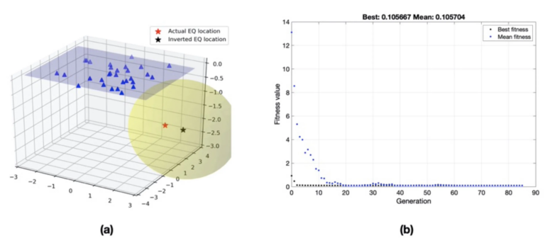
Determining the meteor’s path required integrating innovative analytical methods. We used both a graphical method and a Genetic Algorithm (GA)-based optimization approach to precisely reconstruct its trajectory. This dual-method analysis allowed us to pinpoint the meteor’s termination point at coordinates 25.33°N, 121.26°E, roughly 20 kilometers offshore from Tamsui.
The trajectory parameters revealed that the meteor entered the atmosphere at a steep elevation angle of 70° and followed an azimuth of 303°—moving northwest. This high-elevation angle suggested a near-vertical descent, likely producing the distinctive sonic booms heard across Tamsui.

Estimating the Meteor’s Impact Energy
In addition to its path, we estimated the meteor’s energy. Using infrasound signal characteristics, specifically the signal period at maximum amplitude, we applied a scaling law originally developed for nuclear tests. The impact energy was calculated to be around $latex 5 \times 10^10$joules, equivalent to a magnitude 4 earthquake. This corresponds to a meteor approximately 0.5 meters in diameter and an estimated pre-atmospheric mass of 250 kilograms.
Broader Implications
Our findings underscore the importance of integrated geophysical monitoring networks for capturing and analyzing atmospheric phenomena. The combination of seismic and infrasound data provided a comprehensive picture of this event, highlighting the potential for such networks to study other rare, high-energy atmospheric events.
This research also emphasizes the need for interdisciplinary methods. By combining geophysical techniques with optimization algorithms, we reconstructed a detailed picture of an event that lasted mere seconds but left a lasting impression.
References
[zotpress items=”{9687752:XAR3WS6N}” style=”apa”]


I am sure this post has touched all the internet visitors, its really really fastidious article on building up new website.
xbyxYkGOcNUaocUAfmWK
0l9xf9
I simply could not leave your website before suggesting that I actually enjoyed the standard information an individual supply for your guests? Is going to be again continuously to inspect new posts
All of the instances, males have simply no thought just how much girls desire mainly and for flowers blooms don’t be seemingly the best type of items for the menfolk.
I like meeting useful info, this post has got me even more info!
8aiuq4
Way cool! Some very valid points! I appreciate you penning this article plus the rest of the website is also very good.
Greetings! Very useful advice in this particular article! It’s the little changes which will make the most important changes. Thanks a lot for sharing!
Hi, I do think this is an excellent website. I stumbledupon it 😉 I may return yet again since i have bookmarked it. Money and freedom is the best way to change, may you be rich and continue to help others.
Ahaa, its good dialogue concerning this piece of writing at this place at this webpage, I have read all that, so now me also commenting at this place.
This is a topic that’s close to my heart… Thank you! Exactly where are your contact details though?
I’ll immediately grab your rss as I can’t find your email subscription hyperlink or newsletter service. Do you have any? Please permit me know so that I may subscribe. Thanks.
I will immediately clutch your rss as I can not in finding your e-mail subscription link or newsletter service. Do you’ve any? Please permit me know so that I may subscribe. Thanks.